Satellite Images used in Rangeland Health Mapping
May 11, 2020
Methodology:
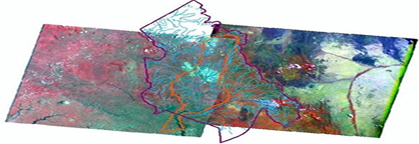
The study covered the Okok River sub-catchment drained mainly by the River Okok that runs through four Districts of Napak, Kotido, Kaabong and Abim in the Karamoja region, North Eastern Uganda. Consultations with local communities were at Parish level through meetings and participatory rangeland health mapping and action planning.
The action planning process included participatory community-based transect walks, resources and rangeland mapping, identification of planning goals, objectives, actions for identified problems, scheduling, resources needed and monitoring and evaluation planning.
Sampling for Parish level consultations was guided by a review of relevant base-maps and indicators provided in a previous study of 2009 by IUCN. Based on the IUCN study, soil erosion was identified as a unifying factor considering scientific and indigenous knowledge used to describe the status of rangelands in Karamoja. Therefore, a modeled soil erosion map was used as the primary basis for sampling of the Parishes into degraded and healthy rangeland patches.
Objective
- Develop a participatory environmental management plan which includes mapping of degraded and healthy rangelands;
- Establish the status (healthy or degraded) of the rangeland;
- Determine the scale/extent of the different rangeland patches of Okok sub-catchment;
- Identify and analyze the causes and consequences of rangeland degradation (and rangelands health), and provide recommendations on how to implement future interventions
Related Articles
January 11, 2023
Webinar : What’s New in ArcGIS Pro 3.0
What's New in ArcGIS Pro 3.0 Thursday, 12 January 2023 |11am -12pm EAT This webinar will highlight new performance and
Read Article
May 11, 2020
ESIPPS Executive Director amongst medalists at Women’s day celebrations
At ESIPPS International Ltd we joined Women’s day celebrations with a special purpose to congratulate our own Executive Director, Dr.